Sampling Dates for 2019 and Information on DNA Extracted
Winter: March 22nd, 23rd, 29th, and 30th. Extraction spreadsheet here
Spring: May 28th and 29th, June 3rd and 4th. Extraction spreadsheet here
Summer: August 19th, 20th, 29th, and 30th. Extraction spreadsheet here
Fall: October 21st, 23rd, 28th, and 30th. Extraction spreadsheet here
Sampling Dates for 2020 and Information on DNA Extracted
Winter: February 17th, 18th, 24th and 26th
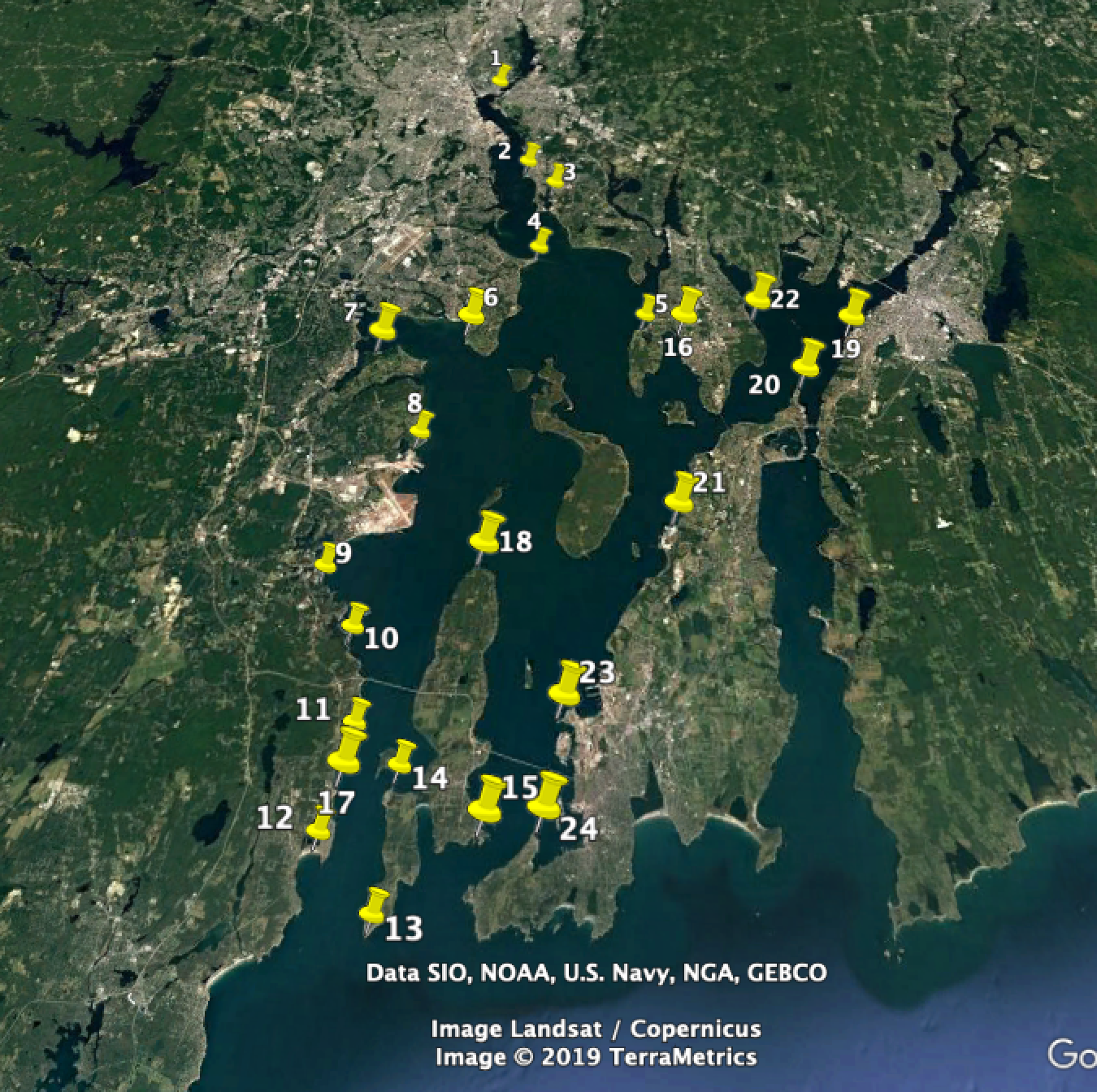
Sampling Locations: You can also download the Google Earth coordinates in this .kmz file

And here is a table of all the GPS coordinates as well
| Google Earth # | Location | Longitude | Latitude |
|---|---|---|---|
| 1 | India Point Park | 71°23’28.10”W | 41°49’2.28”N |
| 2 | Sabin Point Park | 71°22’8.58”W | 41°45’58.47”N |
| 3 | Haines Point Boat Ramp | 71°21’10.51”W | 41°45’13.68”N |
| 4 | Conimucut Point Park | 71°21’30.58”W | 41°42’58.53”N |
| 5 | Colt State Park | 71°18’0.60”W | 41°40’54.55”N |
| 6 | Near Warwick Lighthouse | 71°23’27.00”W | 41°40’31.75”N |
| 7 | Goddard Memorial State Park | 71°26’4.38”W | 41°39’59.99”N |
| 8 | Calf Pasture Point Beach | 71°24’26.00”W | 41°38’4.01”N |
| 9 | North Kingstown Beach | 71°26’35.86”W | 41°33’57.00”N |
| 10 | Ed’s Beach | 71°25’47.75”W | 41°33’6.32”N |
| 11 | Saunderstown Yacht Club | 71°25’4.61”W | 41°30’29.48”N |
| 12 | Kelly Beach | 71°25’26.27”W | 41°28’22.83”N |
| 13 | Beavertail State Park | 71°24’1.39”W | 41°27’6.50”N |
| 14 | Beaverhead | 71°23’48.64”W | 41°29’35.70”N |
| 15 | Fort Wetherill State Park | 71°21’36.67”W | 41°28’44.02”N |
| 16 | Mill Pond | 71°16’51.36”W | 41°40’45.56”N |
